TNI Bureau: The India Meteorological Department (IMD) has predicted light to moderate rainfall at a few places of Odisha between October 23 and October 25.
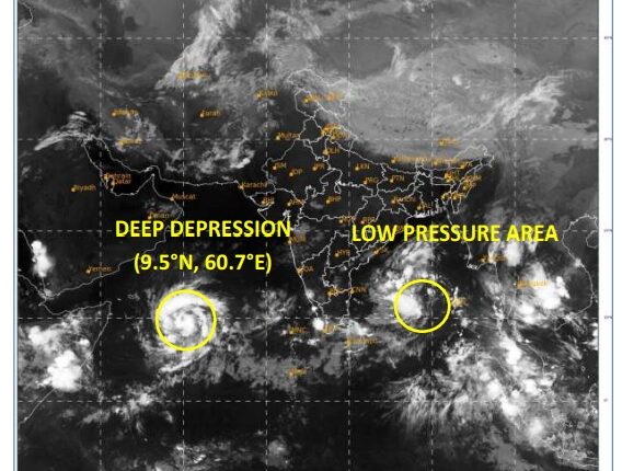
The rainfall would occur in the state under the influence of deep depression over southwest Arabian Sea and the low pressure Area over southwest and adjoining southeast Bay of Bengal.
Here is the details of the latest bulletin of the weather department:
(A) Deep Depression over southwest Arabian Sea:
The deep depression over southwest Arabian Sea moved west-northwestwards with a speed of 11 kmph during past 6 hours and lay centered at 2330 hours IST of 20th October over the same region, near latitude 9.5°N and longitude 60.7°E about 820 km east-southeast of Socotra (Yemen), 1100 km south-southeast of Salalah Airport (Oman) and 1180 km east-southeast of Al Ghaidah (Yemen).
It is very likely to move west-northwestwards and intensify into a cyclonic storm over southwest
Arabian Sea during next 06 hours. Continuing to move west-northwestwards, it is likely to intensify into a severe cyclonic storm in the evening of 22nd October. Thereafter, it would move north-northwestwards from 24th morning towards south Oman and adjoining Yemen coasts and cross Oman-Yemen coasts between Salalah (Oman) and Al Ghaidah (Yemen) around early
hours of 25th October.
Following warnings has been issued:
(i) Wind warning (warning graphics enclosed):
Southwest Arabian Sea:
Squally wind speed reaching 55-65 kmph gusting to 75 kmph is prevailing and likely to increase gradually becoming Gale Wind speed reaching 60-70 kmph gusting to 80 kmph by morning of 21st, 80-90 kmph gusting to 100 kmph by morning of 22nd October. It is likely to decrease gradually thereafter.
Westcentral Arabian Sea:
Squally wind speed reaching 50-60 kmph gusting to 70 kmph is prevailing and likely to become Gale wind speed reaching 80-90 kmph gusting to 100 kmph by morning of 22nd, becoming 95-105 kmph gusting to 115 kmph by morning of 23rd and further 105-115
kmph gusting to 125 kmph in the evening of 23rd October. Thereafter, it is likely to decrease gradually becoming Gale wind speed reaching 85-95 kmph gusting to 115 kmph by 24th evening and 70-80 kmph gusting to 90 kmph in the morning of 25th October.
(ii) Sea Condition
Southwest Arabian Sea:
Very rough to high sea condition is prevailing and likely to become high to phenomenal from morning of 21st to 23rd October. It is likely to improve gradually thereafter.
Westcentral Arabian Sea:
Rough to very rough sea condition is prevailing and it is likely to become very rough to phenomenal from 22nd till 25th evening.
(iii) Fishermen Warning (Graphics attached):
Fishermen are advised not to venture into
Southwest Arabian Sea till 23rd October.
Westcentral Arabian Sea till 25th evening.
Those out at sea are advised to return to coast.
(B) Low Pressure Area over southwest and adjoining southeast Bay of Bengal
The low pressure area over southwest and adjoining southeast Bay of Bengal persists over the same region at 2330 hours IST of 20th October, 2023. It is very likely to move northwestwards and intensify into a depression over westcentral Bay of Bengal around 22nd October.
Thereafter, it is likely to move north-northeastwards towards Bangladesh and adjoining West
Bengal coasts during subsequent 3 days.
Following Warnings has been issued by the IMD:
(i) Rainfall Warning
Nagaland, Manipur, Mizoram & Tripura:
Light to moderate rainfall at most places with isolated heavy rainfall is likely on 24th and 25th October.
Coastal Districts of Odisha: Light to moderate rainfall at a few places is likely on 23rd and at many places on 24th & 25th October.
Coastal Districts of West Bengal:
Light to moderate rainfall at many places is likely on 24th and 25th October.
(ii) Wind warning (warning graphics enclosed):
Southwest and adjoining southeast Bay of Bengal:
Support Independent Journalism? Keep us live.
Squally wind speed reaching 45-55 kmph gusting to 65 kmph is likely to prevail near the system on 21st & 22nd and 50-60 kmph gusting to 70 kmph on 23rd October. It is likely to decrease gradually thereafter.
Westcentral Bay of Bengal:
Squally wind speed reaching 40-50 kmph gusting to 60 kmph is likely to prevail on 21st
October. It is likely to gradually increase becoming 45-55 kmph gusting to 65 kmph on 22nd and 50-60 kmph gusting to 70 kmph on 23rd & 24th October.
North Bay of Bengal and along & off Odisha, West Bengal and Bangladesh coasts:
Squally wind speed reaching 45-55 kmph gusting to 65 kmph is likely to prevail from 24th to 26th October.
(iii) Sea Condition
Southwest and adjoining southeast Bay of Bengal:
Moderate to rough sea condition is likely to prevail near the system on 21st and it is likely to become rough to very rough on 23rd October. It is likely to improve gradually thereafter.
Westcentral Bay of Bengal:
Rough sea condition is likely to prevail on 21st October. It is likely to become rough to very rough from 23rd October.
North Bay of Bengal and along & off Odisha, West Bengal and Bangladesh coasts:
Rough to very rough sea condition is likely from 24th to 26th October.
(iv) Fishermen Warning (Graphics attached):
Fishermen are advised not to venture into
Southwest and adjoining southeast Bay of Bengal till 23rd October.
Westcentral Bay of Bengal from 21st October onwards.
North Bay of Bengal and along & off Odisha, West Bengal and Bangladesh coasts from 24th to 26th October.
Those out at sea are advised to return to coast.
Both the systems are under continuous surveillance and the next bulletin will be issued at 0830 hours IST of today, the 21st October, 2023.


Comments are closed.