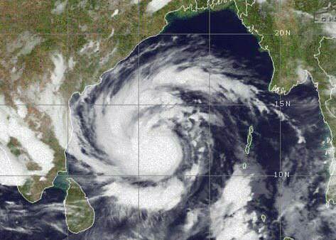
TNI Bureau: Extremely severe cyclonic storm Amphan is likely to intensify into ‘Super Cyclone’ in the next 12 hours, informed India Meteorological Department (IMD) DG Mrutyunjay Mohapatra on Monday.
From 5.30 pm on Monday till 5.30 am on Tuesday, Amphan will be a ‘Super Cyclone’ with wind speed ranging from 220 kmph to 265 kmph. However, it will be in the sea during this 12 hours.
The Coastal Odisha is likely to experience light to moderate rainfall at many places from 18th May evening.
The north coastal Odisha districts Jagatsinghpur, Kendrapara, Jajpur, Bhadrak, Balasore & Mayurbhanj Districts to witness heavy to very heavy rainfall on 19th & 20th May 2020.
Support Independent Journalism? Keep us live.
The wind speed will gradually increase from 75 to 85 kmph gusting to 95 kmph from 20th morning along and off north Odisha. It will gradually increase thereafter becoming 110 to 120 kmph gusting to 135 kmph along & off the above mentioned districts of North Odisha.
Twelve coastal districts of Odisha — Ganjam, Gajapti, Puri, Jagatsinghpur, Kendrapara, Bhadrak, Balasore, Mayurbhanj, Jajpur, Cuttack, Khurda and Nayagarh — are on high alert.
The fishermen are advised not to venture into south Bay of Bengalduring next 24 hours, to central Bay of Bengalduring 17th to 18thMay and into North Bay of Bengal during 18th to 20th May 2020.
The cyclone is likely to make a landfall somewhere between Digha in West Bengal and Hatiya Islands in Bangladesh on Wednesday.


Comments are closed.